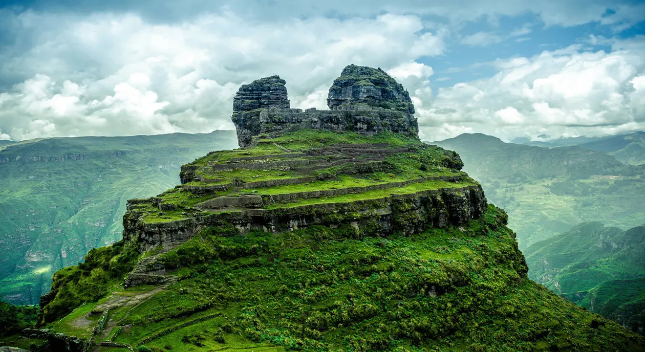
WAQRAPUKARA: THE SACRED TEMPLE AMONG THE MOUNTAINS
If there is a truly unique place on Earth, where nature and the work of man merge in an extraordinary way, that is Waqrapukara. This impressive monument, nestled among mountains and canyons of the southern Andes, is a living testimony of the cultural and spiritual development of ancient civilizations that inhabited the region from around 3000 B.C., long before the arrival of the Incas.
Over time, different pre-Inca cultures and later the Incas continuously occupied this territory, leaving traces of their architecture, beliefs, and worldview. Waqrapukara was an important ceremonial center, dedicated to the god Tecsi Pachacamac Wiraqocha, where offerings to the sun and the moon were performed. Its relevance was such that it came to be considered one of the most important sacred spaces, second only to the Inca temple of Raqchi.
Ubicación del Paisaje Arqueológico de Waqrapukara
El Paisaje Arqueológico de Waqrapukara se encuentra ubicado en la margen derecha del río Percca, en el sector del fundo Percca, dentro de la comunidad de Huayqui, distrito de Acos, provincia de Acomayo, en el departamento de Cusco.
Este importante sitio arqueológico se sitúa a una altitud aproximada de 4,110 metros sobre el nivel del mar, rodeado de imponentes cañones y montañas andinas.
Sus coordenadas geográficas en sistema UTM son Este: 0209008.2600 y Norte: 8448423.2630, lo que confirma su ubicación estratégica en una zona de gran valor paisajístico, cultural y espiritual.
Meaning of the word Waqrapukara
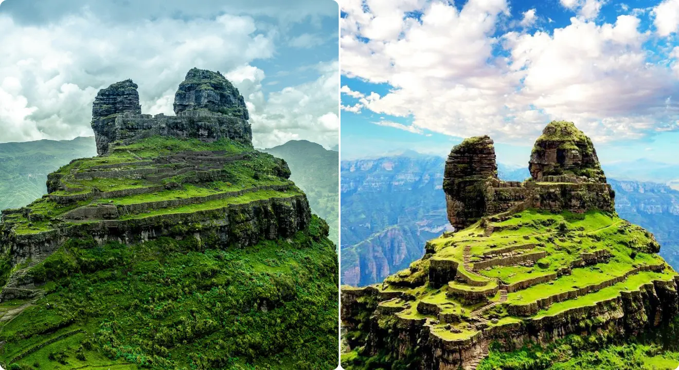
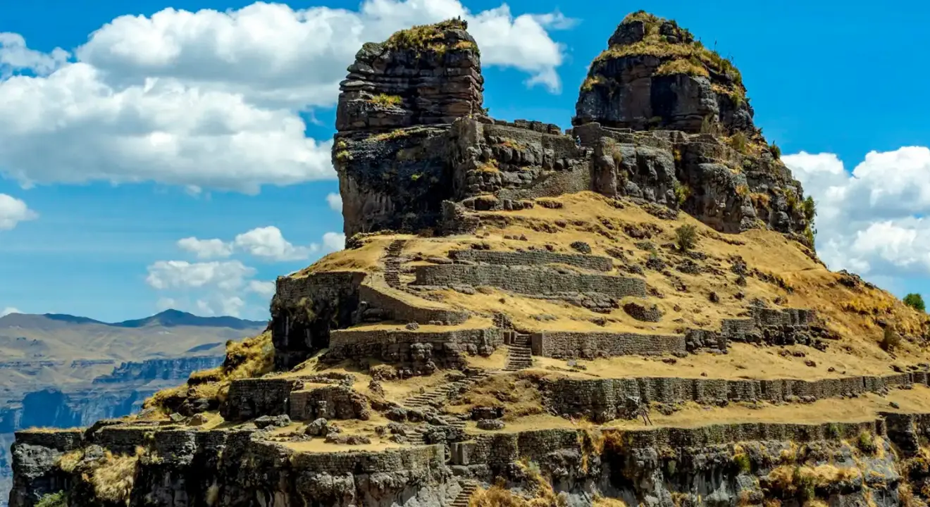
The name Waqrapukara has a deep linguistic, symbolic, and cultural meaning within the Andean world. It comes from Quechua, the ancestral language of the Andes, and is composed of two terms: waqra (or huacra), which means horn, and pukara, which translates as fortress, elevated place, or defensive and ceremonial site. Therefore, its most accepted meaning is “Fortress of the Horns.”
This denomination directly refers to the two imposing rock formations that stand out in the landscape and which, due to their natural shape, resemble large horns. These structures are not only a distinctive geological feature, but also possess strong symbolic value, since in the Andean worldview hills and rock formations were considered apus, or sacred protective entities.
Before being known as Waqrapukara, the site received the name Llaqtapukara. The term llaqta means town or populated center, which indicates that various families inhabited the place, while pukara alludes to its ceremonial and strategic function. This suggests that Waqrapukara was not only a sanctuary, but also a space of permanent occupation and social organization.
Another name associated with the site is Huayqui or Huayqe, a Quechua word that means brother. This name would be related to the two twin rock formations, symbolically interpreted as brothers, reinforcing the idea of duality, a fundamental principle in the Andean worldview (hanan–hurin, above–below, masculine–feminine).
During the Inca period, especially under the government of Wayna Qhapaq, Waqrapukara gained greater relevance and was transformed into a ceremonial and astronomical observation center, linked to the worship of the sun, the moon, and the creator deity Tecsi Pachacamac Wiraqocha.
Waqrapukara through time: a sanctuary forged by ancient cultures
1. The first inhabitants and the origin of the settlement
Long before Inca rule, Waqrapukara was inhabited by diverse ethnic groups, including the Chelq’es and Maskas, who strategically occupied these Andean territories. Later, with the consolidation of the K’ana nation, new clans settled in the Pomacanchi and Acomayo area, giving rise to the Qanchi ethnicity.
The Qanchis established their paqarinas, or places of origin, in nearby areas such as Tambomayo, Puma Orqo, Willkacalle, Suyt’upukara, Qero, and Pumawasi. From Waqrapukara, they began expanding their territory to highland zones, building defensive pukaras such as Machupitumarca, Salqapukara, and the heights of Salqamayo.
2. Waqrapukara as a fortress and strategic center
During the Late Intermediate Period, Waqrapukara gained great political and defensive relevance. The Qanchis maintained contact with other peoples, such as the Parureños, who came to the site to make offerings of Colcha-style ceramics. The presence of the Killke or early Incas is also recorded, who occupied the site before the final expansion of the Inca Empire.
Initially conceived as a llaqta (populated center), around 1000 B.C., during the period of the Auqarunas, Waqrapukara was transformed into a pukara or fortress, in order to protect its territory. During this period, intense conflicts arose between the Qanchis, K’anas, and Chumpiwillkas, who coveted the area for its fertility and agricultural production, especially maize.
3. The Inca stage and monumental transformation
Waqrapukara became one of the last refuges of resistance for the Qanchi ethnicity, led by Ttito Qosñipa, against the advance of the Inca army. After the incorporation of the Qanchis into the Tahuantinsuyo, the Incas exercised indirect control over the region.
When T’ito Qosñipa reached the rank of general in the Inca army, important architectural improvements were made in Waqrapukara. Thanks to this, today it is possible to observe high-quality Inca constructions that integrate harmoniously with pre-Inca structures, reinforcing its ceremonial and strategic character.
4. Changes during the colonial period
During the colonial period, in 1581, the province of Acos was recorded in the provisions of Viceroy Toledo as part of the repartimiento of Cusco. Later, in 1613, an ecclesiastical reorganization divided the region into 13 corregimientos, incorporating Acomayo within the fourth corregimiento of Quispicanchi.
5. Waqrapukara today: a sacred and natural destination
Today, Waqrapukara is recognized as an Archaeological Landscape, protected by the Ministry of Culture of Cusco and safeguarded by the communities of Acomayo and Huayqui. It is an emerging tourist destination, still little visited, allowing one to enjoy the site with tranquility and at low cost.
In addition to its historical value, the natural surroundings are impressive: the rock outcrops serve as a habitat for Andean condors, which usually soar over the area at midday. With a bit of luck, visitors can observe more than 20 condors gliding through the sky, offering a unique and unforgettable experience.
How to get to Waqrapukara from Cusco
Access to the Archaeological Landscape of Waqrapukara is made from the city of Cusco by taking the route towards Sicuani. Along the way, it is necessary to turn off at the Chuquicahuana bridge, from where four main routes open to reach the archaeological site. Each offers unique landscapes and different levels of hiking.
1. Route through Acos (short walk)
From the district of Acos, continue towards the populated center of Ch’acco, passing through Llapaypampa and Campi – P’alta Cancha, until reaching the Huayqui Community.
From this point, start an uphill walk of approximately 30 minutes, followed by a final stretch of 15 minutes, until reaching Waqrapukara.
Ideal for those looking for a short and accessible walk.
2. Route through Acomayo (two alternatives)
Upon arriving at Acomayo, there are two options:
- Option 1: Take the Huáscar branch, continue towards the populated center of K’enter, and end the route at Waqrapukara.
- Option 2: Enter through the Pitumarca Community, passing through Paclla, until reaching the archaeological complex.
- Both routes offer beautiful rural landscapes and Andean views.
Route through Pomacanchi (the most popular)
From the district of Pomacanchi, there are also two alternatives:
- Most used route: Acomayo – Churacca – Santa Lucía – Punta road of Santa Lucía. From there, a walk of approximately 45 minutes is made to Waqrapukara.
- Alternative route: Entry through the populated center of Chosecani, with fewer visitors.
- This is the most recommended route for tourists.
Route through Sangarará (more adventurous)
- From the district of Sangarará, advance along a dirt road until the sector of Llank’ipata. From there begins a walk of approximately 2 hours downhill to Waqrapukara.
- Recommended for travelers with good physical condition and a taste for adventure.
Traveler tip: Arrive early at Waqrapukara to enjoy the landscape without crowds and see the condors flying at midday. Bring water, sunscreen, warm clothing, and good footwear.
Best time to visit Waqrapukara
The best season to visit Waqrapukara is during the dry season, which runs from May to September, when the weather is more stable and conditions for hiking are optimal.
Dry season (May to September)
- Mostly sunny and clear days
- Lower risk of rain, mud, or fog
- Safer and more accessible paths
- Excellent visibility of the Andean landscape
- Higher probability of observing condors flying, especially at midday
- The months of June, July, and August are the most recommended for photographers and hikers. However, mornings and nights can be cold, so it is important to bring warm clothing.
Rainy season (November to March)
- Frequent and intense rains
- Slippery paths and greater physical effort
- Possible fog that reduces visibility
- Although the landscape looks greener, access can become complicated and less safe.
Traveler tip: To enjoy Waqrapukara safely, with good weather and spectacular views, the ideal is to visit it between May and August, leaving early and well prepared for the altitude and the cold.
What to see in Waqrapukara?
Waqrapukara is one of the most impressive and mystical archaeological landscapes in Cusco. It is not just an archaeological site, but a sacred space where architecture, nature, and Andean spirituality merge exceptionally. Each sector of the complex reveals the ceremonial, strategic, and symbolic importance that this place had over time.
The imposing archaeological landscape
Waqrapukara was an important ceremonial center dedicated to the god Teqsi Pachacamaq Wiraqocha, the creator deity of the world according to Andean cosmology. This sanctuary was associated with the worship of the Sun and the Moon, where ceremonies and offerings of camelids such as llamas and alpacas were carried out, following ancient pre-Inca and Inca rituals. Its location on a rocky promontory reinforces its sacred character and its connection to the spiritual world.
Main sectors and spaces of Waqrapukara
1. Main plaza
Located at the highest part of the complex, it is the ceremonial heart of the site. It is surrounded by imposing horn-shaped rock outcrops, known as waqras, which give the place its name. In this space, rectangular enclosures with double and triple jambs can be observed, an architectural feature reserved for buildings of great importance. The plaza was delimited by retaining walls and was an exclusive space for religious ceremonies, astronomical rituals, and elite gatherings.
2. Ceremonial gateways
Located at the ends of the main plaza, these finely worked stone gateways stand out for their double and triple trapezoidal jambs. Their design reflects Inca influence and their ritual function, associated with ceremonies dedicated to the Sun and the Moon.
3. Sacred enclosure of Wiraqocha
Located to the east of the main plaza, this sector was one of the most sacred spaces of the complex. It includes a priestly hall with niches and a stone altar located in a small square plaza. Offerings and rituals of great spiritual significance were performed here.
4. Natural towers
Two circular-shaped rock formations rise at the south and northeast ends of the site. Although they have no visible access, their strategic location suggests that they were used as lookout points. From there, the entire environment was visually controlled, reinforcing the defensive and ceremonial character of Waqrapukara.
5. Ceremonial enclosures
Distributed mainly at the north and south ends of the main plaza, these rectangular enclosures fulfilled ritual functions. Offerings were prepared in them, and ceremonies prior to the main religious events took place. Some have niches oriented towards specific points, which reinforces their symbolic importance.
6. Residential areas
The complex also preserves circular and rectangular dwellings, located on platforms and terraces. These spaces were used as residences, pottery workshops, and textile production areas, evidencing a permanent and organized occupation of the site.
7. Uña Waqra
This sector is located to the east of the main complex and is connected by a rock outcrop that acts as a natural bridge. Here, pre-Inca structures, passageways, and terraces can be observed, later integrated through Inca walls.
8. Agricultural terraces
Located to the southeast, the terraces are distributed across several levels and have water channels and stairways. They fulfilled an agricultural function, allowing the cultivation of products such as corn and beans, and demonstrate mastery of the Andean environment.
9. Funerary contexts
On the cliffs that are part of the archaeological landscape, funerary structures attached to the rock can be identified. Although many were looted, evidence still exists that allows understanding the funerary practices of ancient populations.
10. Quarry
Located to the northwest of the site, it was the place where stone was extracted for the construction of the complex. From here, the ancient Inca road surrounding the rock outcrop can be seen, integrating the site into a larger road network.
11. Natural viewpoint
Located at the top of the terraces, this point offers a panoramic view of the valley and the surrounding canyon. It is one of the most striking spaces for visitors.
12. Pacarina
This rock shelter is considered the mythical place of origin of the Qanchis ethnicity. Inside is a lithic altar where ceremonies were held in honor of Pachamama, reinforcing the spiritual character of the place.
Architecture of Waqrapukara
The architecture of Waqrapukara reflects different stages of occupation and transformation over time. The gateways with double and triple jambs, retaining walls, superimposed enclosures, and integration of pre-Inca and Inca structures evidence continuous use of the site. The entire ensemble shows careful planning and a deep adaptation to the natural landscape.
1. Hidden archaeological treasures on the way to Waqrapukara
Along the route from Cusco to Waqrapukara, especially around the Pomacanchi lagoon, there are several little-known archaeological sites that reflect pre-Inca and Inca occupation of the area. These spaces were linked to territorial control, ritual activities, and agricultural use of the valley.
2. Pumachapi Pucará
Located northwest of the town of Pomacanchi, Pumachapi Pucará rises on a hill of natural terraces. Its name refers to the puma, a sacred animal in Andean cosmology. On the surface, fragments of pottery, worked stones, obsidian flakes, and quartz have been identified, suggesting a primarily ritual and ceremonial function. From this point, a panoramic view of the valley formed by the Pumachapi and Qayoqa rivers is obtained, which would also have given it strategic value.
3. Q’anchoqa Pucará
This site is located southeast of the town of Pomacanchi. It has natural terraces and abundant surface archaeological material, such as pottery and obsidian fragments, evidencing prolonged occupation. Its location suggests a complementary role within the defensive and ceremonial system of the area.
4. Conchacalla Pucará
Located southeast of the district capital, Conchacalla Pucará sits on a high hill. At the top, circular structures built with diorite stone stand out, associated with residential and ceremonial spaces. Its visual domain covers both the Pomacanchi lagoon and the surrounding plain. On the slopes of the hill, hydraulic channels, crystal-clear water springs, and tombs attributed to the Inca period are preserved, evidencing a complex system of occupation and landscape management.
5. Terraces of Qero and Hatun Qero
These agricultural terraces were built during the reign of Inca Huáscar and are located in a natural bay of the Pomacanchi lagoon. The place has a special microclimate, ideal for cultivation, and presents a succession of artificial embankments demonstrating the advanced agricultural and hydraulic engineering knowledge of the Incas.
6. Q’atoqa
Located in the northwest area of K’ullupata, Q’atoqa is characterized by elongated platforms and small circular structures that would have functioned as dwellings. These buildings, made of sandstone and limestone, correspond to the Wari period, evidencing occupation prior to the Inca expansion in the region.
Other sites near Waqrapukara
In addition to the spaces mentioned, other archaeological sites of interest can be found around Waqrapukara, such as Ayapukara, Llaqtapukara, Tambopukara, and Kullupata, which together form an important cultural and archaeological corridor still little explored.
These places, although less known than Waqrapukara, enrich the traveler’s experience and allow a better understanding of the historical, ritual, and strategic importance of this southern Andean region.
Flora and fauna around Waqrapukara and Pomacanchi
The natural landscape surrounding Waqrapukara and the Pomacanchi lagoon is part of the high Andean ecosystem, characterized by wide open spaces, hills, ravines, and wetlands. This diversity of environments allows for the presence of varied flora and fauna, ideal for travelers interested in nature and photography.
1. Flora
In the area, natural ichu grasslands predominate, covering much of the slopes and plateaus, accompanied by native shrubs adapted to the cold and dry climate. Near the lagoon and water sources, aquatic plants and riparian vegetation can be observed, playing a key role in ecosystem conservation. During the rainy season, the landscape transforms with intense green tones and the appearance of wildflowers contrasting with the mountainous environment.
2. Fauna
The local fauna is mainly composed of species typical of the Andes. Among mammals, Andean foxes are commonly sighted, as well as traditional livestock such as llamas and alpacas, raised by local communities. Regarding birds, the Pomacanchi lagoon is an important point for observing waterfowl, as well as Andean gulls, wild ducks, and birds of prey flying over the area. With some luck, condors can also be seen gliding over the nearby canyons.
This natural environment makes visiting Waqrapukara and its surroundings a complete experience, where ancestral history and Andean biodiversity complement each other, offering visitors authentic contact with the nature of southern Peru.

What to bring
- Identity document or passport
- Warm clothing in layers
- Windbreaker or rain jacket
- Trekking shoes or sneakers with good soles
- Cap, sunglasses, and sunscreen
- Sufficient water
- Energy snacks
- Small and comfortable backpack
- Cell phone or camera with charged battery
- Trekking poles
What not to bring
- Heavy or unnecessary objects
- Speakers or sound equipment
- Drones without authorization
- Plastic bags and trash
- Jewelry or valuables
- Alcohol or prohibited substances
Traveler tip: Bring cash and your identity document or passport, as on the route to Waqrapukara there are no ATMs or stable signal, and at some access points identification may be requested.
Curious facts about Waqrapukara
- Its name means “horn-shaped fortress” in Quechua, due to the natural silhouette of the mountain.
- It was an important Inca ceremonial center, more than a military fortress.
- It is located over 4,000 m (13,120 ft) above sea level, which explains its impressive views.
- From the top, Andean condors can be seen gliding in the canyons.
- It is still a little-visited site, allowing for a calmer and more authentic experience.
We are accredited by